Tag: Land Patents

John Jacob Goughnour’s Conestoga Tract

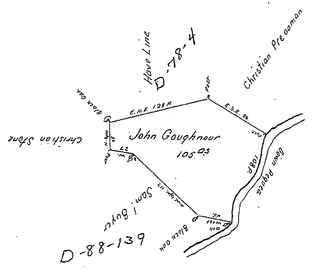
On 24 Jan 1733, John Goughnour warranted 105 acres on a branch of the Pequea in Conestoga (now Pequea) Township, Lancaster County, Pennsylvania, recorded in Lancaster County Warrants #G14. Three days later, John Taylor surveyed the property, noting it adjoined Christian Preaaman [sic], Have Line [sic], Christian Stone, and Samuel Buyer.1

John Jacob Goughnour's Conestoga tract survey

John Jacob Goughnour’s Conestoga tract survey

On 15 April 1761, Jacob Gouchnour patented these 105 acres.2 Jacob purchased another 167.5 acres in Conestoga from Christian Hoober on 26 Nov 1761.3 [see “Christian Preaaman” on map] This tract had been warranted to John Smith in 1734 and patented to Jacob Huber in 1759.

Jacob Goughnour had died prior to 4 Nov 1780 when his heirs—Jacob & Margaret Goughnour, Christian Goughnour, Henry & Ann Goughnour, Abraham Goughnour, Tobias Goughnour, Christian & Catharine (Goughnour) Hess, and Joseph Goughnour—sold 50 acres of this tract, adjoining Samuel Byer, to his son John Goughnour.4

On 12 Mar 1781,  John & Elizabeth Gochenour sold this 50 acres, adjoining Samuel Buyers, to his brother Adam Gochenour & Henry Rush, all of Conestoga Township.5 Adam and the Rushs held onto the property for a little over a year before selling it to Christopher Ort on 23 Aug 1782.6

Christopher Ort, a mason, and Catharine his wife sold this 50 acres to Daniel Musser of Strasburg Township on 21 Nov 1795.7

Jacob Boyer’s Conestoga/Martic Tract

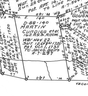
On 22 November 1717, Martin Kendig (Kendick, Kendrick, Cundigg) and John Herr (Heer) were warranted 5,000 acres in Lancaster County by the Proprietaries of Pennsylvania. They, in turn, transferred this land to their fellow immigrants. On the 12th of 9mo (November) 1720, four tracts on the Pequea were surveyed in the right of Martin Kendig and Hans Heer to Hans Boyer, Jacob Hoober, Martin Boyer/Abraham Smith, and Christian Stone/Jacob Boyer.1

Jacob Boyer's Conestoga tract

Jacob Boyer’s Conestoga/Martic tract

Sometime between 1720 and 1735, the land was passed from Christian Stone to Jacob Boyer. “Jacob Biers” patented 162 acres on Pequea Creek on 1 Oct 1735.2 Jacob Boyer apparently lived on this tract for his entire life.

On 20 Jun 1772, Jacob (the elder) and his wife Catharine sold 112 acres from their two tracts—they owned another tract adjoining the first directly to the south in Martic Township—to their son Henry Boyer.3 This piece of property adjoined that of Jacob Boyer Jr., John Jameson, and Samuel Boyer, and lay along the eastern edge of Jacob Sr.’s two tracts.

On the same date, Jacob and Catharine also sold 160 acres from their two tracts to Jacob Boyer Jr. This piece of land included all the land north of Pequea Creek and a strip south of the creek between those of Henry Boyer (to the east) and one previously sold to Abraham Smith (to the west).4

Jacob was apparently preparing for the future in Jun 1772. He also wrote his will at that time. The will abstract names his wife Catharine, children: Jacob, Henry, Barbara, Anna, Mary, Catharine and Elizabeth wife of Jacob Steiner, and grandchildren: Cornelius and Frederick Steiner. The will was probated 30 Oct 1775 and named Catharine and son-in-law Jacob Steiner as executors.5

Several years later, on 22 Oct 1781, Jacob [Jr.] and Mary Boyer sold 16 acres from their tract to Rudy Miller.6 By metes and bounds this piece was situated in the northwest corner of the plot, north of Pequea Creek. It adjoined land of Rudy Miller, John Line and Pequea Creek.

On 3 Mar 1806, Rudy Miller’s heirs—Rudolph Miller, Stephen & Mary (Miller) Rine, and Hugh & Barbara (Miller) Evans—sold their interest in Rudy Miller’s four tracts of contiguous land in Conestoga and Martic townships, including this 16 acres, to John Miller, another of Rudy Miller’s children.7

Jacob Hoober’s 1736 Land Patent

Having written about how to use the online land records at the Pennsylvania State Archives, it’s only fair that I provide examples of what each document entails.

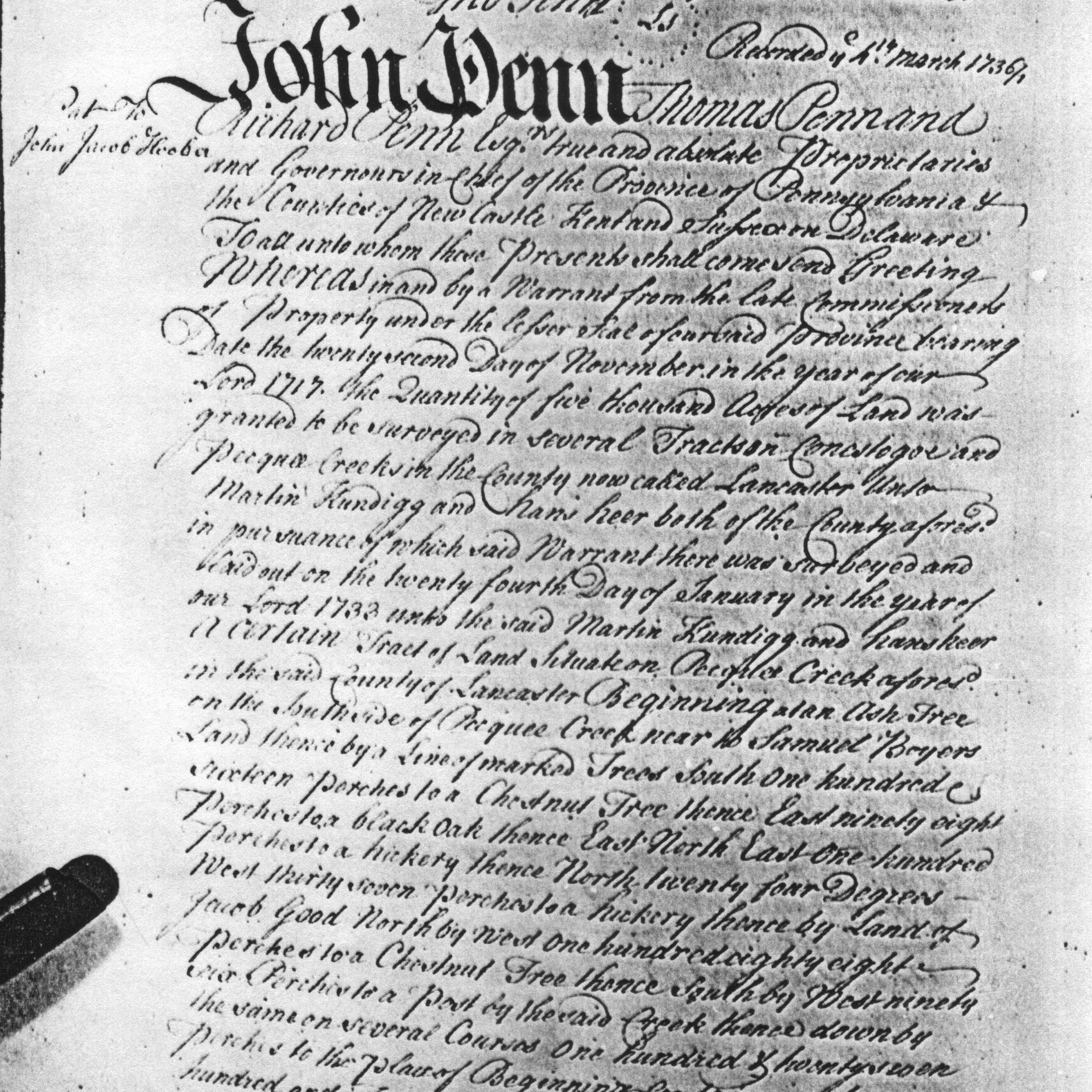
John Jacob Hoober land patent

Jacob Hoober’s land patent

This is a transcription of the John Jacob Hoober’s patent for 210 acres situate on the southside of Pequea Creek in present-day Providence Township. Jacob Hoober received a warrant for the tract 24 Jan 1733. It was surveyed to him on 28 Jan 1733.

[150]

“John Penn Thomas Penn and
Richard Penn Esqr true and absolute Proprietaries
and Governours in chief of the Province of Pennsylvania &
the Counties of New Castle Kent and Sussex on Delaware

To all whom these Presents shall come send Greeting
Whereas in and by a Warrant from the late Commissioners
of Property under the lesser Seal of our said Province bearing
Date the twenty second Day of November int he year of our
Lord 1717 the Quantity of five thousand acres of Land was
granted to be surveyed in several Tracts on Conestogoe and
Pequea Creeks in the County now called Lancaster unto
Martin Kundigg and hans heer both of the County adoresd.
in pursuance of which said warrant there was surveyed and
laid out on the twenty fourth Day of January in the year of
our Lord 1733 unto the said Martin Kundigg and hans heer
a certain Tract of Land situate on Pequea Creek aforesd
in the said County of Lancaster Beginning at an Ash Tree
on the southside of Pequea Creek near to Samuel Boyers
Land thence by a line of marked Trees south one hundred
sixteen perches to a Chestnut Tree thence East ninety eight
perches to a black Oak thence East North East one hundred
perches to a hickory thence North twenty four Degrees
West thirty seven perches to a hickory thence by Land of
Jacob Good North by West one hundred eighty eight
perches to a Chestnut Tree thence South by West ninety
six Perches to a Post by the said Creek thence down by
the same on several course one hundred & twenty seven
perches to the place of Beginning containing two
hundred and Ten acres and the allowance of six acres

[151]
in each hundred for Roads and highways as in and by the Survey
thereof remaining in our Surveyor General’s Office and from thence
certified into our Secretary’s Office may appear And Whereas the sd
Martin Kundigg and hans heer by a certain Deed or Instrument
in Writing bearing Date the twenty fourth Day of March in the
Year of our Lord 1734/5 for the consideration therein mentioned did
bargain and sell all their Right Title and Interest of and in the
said two hundred and Ten acres of Land and Premisses with the
appurtenances unto Jacob Hoober als John Jacob Hoober of the
said County of Lancaster his heirs and assignes Now at the Instance
and Request of the said John Jacob Hoober that we would be
pleased to grant him a confirmation of the said two hundred
and ten acres of Land according to the Situation of Lines and Bounds
aforesaid Know ye that in consideration of the sum of twenty one
pounds lawful Money of Pennsylvania to our Use now paid by
the said John Jacob Hoober the Receipt whereof we hereby
acknowledge and thereof do acquit and forever discharge the said
John Jacob Hoober his heirs and assignes by these presents
and also for the yearly Quitrent herein after mentioned and
reserved We have given granted released and confirmed and
by this Presents for Us our heirs and succession Do give
grant & release and confirm unto the said John Jacob Hoober
and his heirs the said two hundred and Ten acres of Land as the
same is now set forth bounded and limited as aforesaid with all
mines minerals Quarries Meadows Marshes Savannahs
Swamps Criples Woods Underwoods Tree and Trees Ways
Waters Water Courses Liberties Profits Commodities Advanta
ges hereditaments and appurtenances whatsoever to the
said two hundred and Ten acres of Land belonging or in any
wise appertaining and lying within the Bounds and Lines
aforesaid / [?] full and clear fifth Parts of all royal Mines
free from all Deduction and Reprisals for digging and
refining the same only excepted and hereby reserved and
also free leave Right and Liberty to and for the said John
Jacob Hoober his heirs and assignes to hawk hunt fish
and fowl in and upon the hereby granted Land and Premises
or upon any Part thereof To have and to hold the said
two hundred Ten acres of Land and Premises hereby
granted / Except before excepted / with the appurtenences
unto the said John Jacob Hoober his heirs and assignes
To the only Use and Behoof of the said John Jacob Hoober
his heirs and assignes forever To be holden of us our
heirs and successors Proprietaries of Pennsylvania as
of our Manner of Conestoga in the County of Lancaster
aforesaid in free and common Soccage [sic] by Fielty [sic] only in
Liew [sic] of all other Services Yielding and paying
therefore yearly to us our heirs and Successors at the Town of
Lancaster after upon the first Day of March in every year

[152]

from the first Day of march last past One English
Silver Shilling for each hundred acres of the same and in
proportion for the Ten acres or value thereof in Coin
current according as the Exchange shall then be between
our said Province and the City of London to such Person
or Persons as shall from Time to Time be appointed
to receive the same and in case of non payment thereof
within ninety Days next after the same shall become
due that then it shall and may be lawful for us our
heirs and successors our and their Receiver or
Receivers into and upon the hereby granted Land and
Premises to reenter and the same to hold & possess
until the said Quitrent and all Arrears thereof together
with the charges accruing by means of such none
payment and Reentry aforesaid be fully paid and
discharged In Witness whereof the said Thomas
Penn by virtue of the Power Authorities to him
granted by the said John and Richard Penn and of his
own right hath caused the Great Seal of the said Province
to be hereunto affixed at Philadelphia this twenty
second Day of October in the Year of our Lord one
thousand seven hundred & thirty six the Tenth Year
of the Reign of King George the second over great
Britain [?] and the nineteenth year of our Government

Tho Penn (seal)

Recorded ye 4th March 1736/7 1

John Jacob Hoober’s land patent

How to Use the Online Land Records at the PA State Archives

If you’ve read my blog, you’ll know that I use land records—a lot! I’ve mentioned warrants, patents and deeds in a number of posts. They’re some of my favorite record groups. And best of all, depending on where your ancestor lived, the records may be available online for free.

This blog post is going to explain how to use the land records available online at the PA State Archives. These records are organized by record and then either by county or volume and surname. They have been scanned and placed online as PDFs by page. The records include:

  • Warrant Registers
  • Copied Survey Books
  • Patent Indexes
  • Patent Tract Name Index
  • Indexes of Selected Original (Loose) Surveys
  • East Side Applications (Register)
  • West Side Applications (Register)
  • Philadelphia Old Rights (Index)
  • Old Rights Index: Bucks and Chester Counties
  • New Purchase Register
  • Original Purchases Register
  • Last Purchase Register
  • Luzerne County Certified Townships
  • Donation Lands
  • Depreciation Land Register
  • Warrantee Township Maps
  • Melish-Whiteside Maps

I’m going to focus on the records in bold.

To understand how to use these records, it’s important to understand how the process worked in Colonial Pennsylvania.1 Technically, William Penn owned all of the land in Pennsylvania. A settler would apply to the land office for land. Before 1687, these applications were typically oral and not recorded. After 1687, they were recorded in the minute books of the Commissioners of Property. The minutes can be found in Pennsylvania Archives, Second Series, Volume 19 and Third Series, Volume 1.

After the application, a warrant was issued to authorize a survey of the land. The warrants I’ve seen specify the name of the warrantee, the location of the desired property (sometimes rather generally), the amount of land, the quit-rent—and sometimes the date from which the rent commences—and the price per acre. The issuance of a warrant, however, does not mean that the applicant actually owned the property.

When a warrant was issued, orders were sent to the surveyor to survey the property and draw a map of the courses and bounds, the acreage, and the neighbors. After a survey was done, the applicant would have to pay for the land and provide evidence of their improvements to the property. In viewing the survey books, there are sometimes multiple surveys of a tract of land. Sometimes the original applicant failed to follow through, sometimes they sold their “rights” to someone else prior to the patent, or sometimes subsequent owners required a re-survey.

Once the survey was complete and the land paid for, a warrant of return was sent to the surveyor general, who in turn sent the survey to the secretary’s office so that a patent could be issued. The patent is the document that transferred ownership of the property to the settler.

So, warrants, patents and surveys deal with transfers of land between the Pennsylvania land office and the settler. Records of land transferred between individuals will be found—if recorded—at the Recorder of Deeds for the appropriate county. This may not be the same as the modern county. For more information on the historical transformation of the counties, take a look at the Genealogical Map of the Counties.

Patents
Ulrich Huber patent reference

Ulrich Hoober, Patent Book A11:408

If you know that your ancestor received a patent for their property, you can begin with the Patent Indexes. How would I know that, you ask. Often, deeds—sometimes several transactions removed from the patent—will reference the original patent for the property. You may have seen something like:

It being the same tract of land which the late Proprietaries of Pennsylvania by their Patent dated the twenty eighth day of September A. Dom. 1744 and recorded at the Rolls Office at Philadelphia in Patent Book A vol 11 page 408 &c did grant & confirm to Ulrich Hoover his heirs and assigns forever…2

If you haven’t seen a reference like this, but want to know if your ancestor was an early landholder, the Patent Indexes are still a good place to start. The Patent Indexes will not only provide the patent book, volume and page number for a patent, but will also identify the name of the original warrantee and the date of the warrant. This will make it possible to locate the warrant and survey if your ancestor was not the original warrantee.

  1. First, go to the Patent Indexes page on the State Archives site. The records are arranged by series, which are arranged by date. Choose the series you want to review.
  2. Next find the list of pages for the first letter of your ancestor’s surname. Be prepared to check multiple spellings if they apply. I’ve found “Brenneman” listed under both “B” and “P.”
  3. Check the available pages to see if your ancestor is listed. Each page is a separate PDF file, so you may need to download and open each file in Adobe Reader if your browser doesn’t have a plugin to view PDF files.
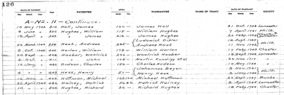
  4. Each listing includes: series and volume, date of patent, page number, patentee name, area in acres and perches, name of warrantee, name of tract (if available), date of warrant, and county.

If you find your ancestor, make note of the series, volume, page and date of the patent. You’ll need this information if you want to order the patent from the Archives. You should also note the name of the original warrantee, the date of warrrant and the county. This will be necessary for the next step.

In the image above, we have a patent for Woolrick Hoober, dated 20 Sep 1744, with 226 acres in Patent Book A11, page 408. We can also see that he is listed as the original warrantee for a warrant dated 19 Sep 1744 in Lancaster County.

Warrants

Woolerick Hoober, Warrant H338

Woolerick Hoober, Warrant H338, Lancaster County

Now that you have the name of the warrantee, warrant date and county, you can look-up the warrant and survey information in the Warrant Registers. These registers cover approximately 70% of all land in Pennsylvania for 1733—1957. If the warrant date is 1733 or later, follow these instructions.

  1. Go to the Warrant Registers page on the State Archives site. The registers are first arranged by county. Click on the link to the appropriate county.
  2. The pages for each register are listed first alphabetically by the first initial of the warrantee’s surname, then chronologically.
  3. Check the pages to see if the warrantee is listed.
  4. Each listing should include: warrant number, warrantee, type of warrant, quantity of land, warrant location, date of warrant, date of return, acreage returned, name(s) of patentee(s), where the patent is recorded (book, volume, page), and where the survey was copied (book, volume, page). Sometimes there are multiple patentees or surveys for each warrant. Sometimes the warrant was vacated and no information is available.

Woolrick Hoober’s listing tells us that he was issued a warrant (#338) to accept a survey of 226 acres in Conestoga Township, dated 19 Sep 1744. The patent was issued 19 Sep 1744 on 226 acres. The patent is listed in Book A11, page 408 and the survey is in book D88, page 127.

If the warrant date was before 1733, you’ll need to check the Old Rights Index for Bucks and Chester counties or the Philadelphia Old Rights Register.

Surveys
Woolrick Hoober, Survey Book D88:127

Woolrick Hoober, Survey Book D88:127

With the location of the survey from the Warrantee register, the next step is a piece of cake.

  1. Go to the Copied Survey Books page.
  2. Select the appropriate page for the book and volume.
  3. Click on the page link.
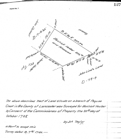
  4. Each survey should provide either a description of the metes and bounds or a drawing of the tract’s boundaries with the calls and the names of the tract’s neighbors. The survey also usually shows the date of the survey, name of surveyor, who the land was surveyed for, the date of the warrant, and the warrantee.

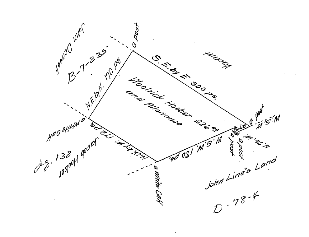
Ulrich’s survey shows that John Line, Jacob Hoober, and John DeHoof were his neighbors at the time of the survey—20 Oct 1728.

Warrantee Township Maps

Maps for some of the townships were drawn up showing all of the original landholders—those who received the property directly from the Proprietors or the Commonwealth—within the context of the present-day townships. Unfortunately, not every township was mapped.
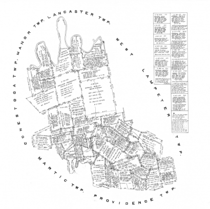
Pequea Warrantee Township Map

Pequea Warrantee Township Map

To find a map of the township were your ancestor held property, you need to know the relationship between the historical township and the modern township. For instance, Ulrich Hoober’s tract was in Conestoga township when he received the patent in 1744. Two modern townships—Conestoga and Pequea—make up the historical 1729 township.3 You can see Ulrich Hoober’s property in the context of the township’s other properties in the Pequea Warrantee Township map.

Don’t forget, using this information you can order a copy of the land warrant or patent from the Pennsylvania State Archives. If you know the reference—warrant number, warrantee and county of warrant for warrants or patentee, patent date, book, volume and page number for patents—you can order an uncertified copy fairly inexpensively. If you don’t have that information, you can also order a search by the staff archivist. That, of course, will cost you more. Warrantee township maps are also available for sale.

If you can visit the state archives in Harrisburg, you can use the information you found through the online records to locate the documents on microfilm, saving time looking up the references so you can research other records.

That’s a fairly quick explanation of warrants, patents and surveys at the Pennsylvania State Archives website. These instructions should work for most properties. However, there will be exceptions (aren’t there always?). If you have questions, leave a comment or drop me a line. I’d be glad to help however I can.

Note: modified to include new PHMC screenshot.

Ulrich Huber’s Conestoga Tract

Last week’s article for the “Along the Pequea” series, traced the land transactions of Hans Line’s property. This week, we’ll follow the transactions of his neighbor, Ulrich Huber.

Ulrich Huber first appears in Conestoga in the 1728 survey of his Conestoga plantation (see figure 1).1 John Taylor surveyed 226 acres, adjoining John Line, John Dehoof, and Jacob Hoober.  However, we can presume he was in Pennsylvania by 1718. He was naturalized with a large group of Mennonite settlers in 1729 who had “transported themselves and estates into the province of Pennsylvania between the years one thousand seven hundred and one thousand seven hundred eighteen.” 2

Woolrich Hoober survey

Figure 1: Woolrich Hoober 1728 survey

Ulrich received a warrant for this property 19 Sep 1744.3 He patented the tract either 19 or 20 Sep 1744.4 He was taxed for property in Conestoga in 1751 and 1754.5

On 16 Nov 1750, Ulrich sold 15 acres to his neighbor Michael Hess.6 On 7 Dec 1754, Michael and Barbara Hess sold their 15 acres from Ulrich to Michael Harnis[h].7 I found no subsequent deed of sale from Michael Harnish for this 15 acres. However, when Ulrich’s tract was sold to John & Henry Brenneman in 1791, it included the entirety of the tract patented to Ulrich Huber.

Ulrich died prior to 18 May 1757.8 On 23 Jun 1759, his heirs—Jacob & Barbara Hover, Henry & Anna [Hover] Shank, Jacob & Maria [Hover] Boyer, Elizabeth Hover, Ulrick Hover and Henry Hover—transferred the land to the eldest son John Hover, witnesses were [Christian?] Line and Michael Shank.9

John and Mary, his wife, held on to this property for nearly a decade before selling it to Melchor and Ann (Good) Brenneman on 10 Oct 1767.10 The Brenneman’s held onto the land until 1783 when they sold it to their daughter and son-in-law John and Eve Bowman on 22 Mar.11 Eight years later, John and Eve (Brenneman) Bowman sold the property to her brothers John and Henry Brenneman.12

John and Henry apparently partitioned the property. John and Catharine Brenneman sold their 113 acres, adjoining Jacob Smith, John Good, George Rathvon, Christian Line, and Abraham Huber, to Henry Zercher on 7 May 1794.13 Zercher later died intestate and John Brenneman bought back the property on 10 May 1806 when Zercher’s heirs refused the land at it’s appraised price.14 John and Catharine then sold the tract to Jacob Heidelbach on 12 May 1806.15

Hans Line’s Conestoga Tract

On 22 November 1717, Martin Kendig (Kendick, Kendrick, Cundigg) and John Herr (Heer) were warranted 5,000 acres in Lancaster County by the Proprietaries of Pennsylvania. They, in turn, transferred this land to their fellow immigrants. Among these was Hans Line.

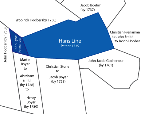
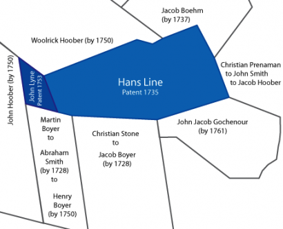
John Taylor surveyed 200 acres on a branch of Pequea Creek for Hans Line on 20 8ber [October] 1728 in right of Martin Kendig and John Herr.1  Adjoining landholders at the time of the survey included: Jacob Boyer (formerly Christian Stone), Abraham Smith (formerly Martin Boyer), and Christian Prenaman. Hans Line patented this tract on 14 April 1735.2 (See lighter blue section on map below.)

Hans Line Conestoga Tract

On 21 December 1750, John Line was warranted 23 1/2 acres, adjoining the 200 acre Hans Line tract.3 This tract was surveyed 23 December 1750 and patented to John Line on 9 April 1753.4,5 (See dark blue section on map above.) At the time of the survey, this tract adjoined land of Henry Boyer, Ulric “Hower” [Hoober], and John “Hower” [Hoober].

The following spring, on 24 March 1754, John Lyne and Barbara his wife sold 200 acres to John Lyne Jr.6 John Lyne Jr. was apparently the son of John and Barbara Lyne. The deeds where John Lyne [Jr.] transfers this land state “…the said John Lyne the father…did grant…unto the said John Lyne (party hereto) by the name John Lyne Jr…

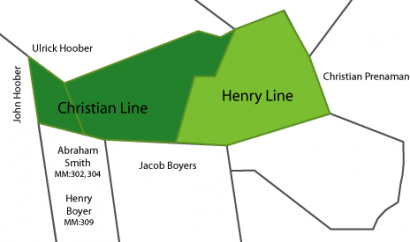
Christian Line and Henry Line tracts

Figure 2: Christian and Henry Line tracts

John Line Jr. apparently decided to retire from farming in 1785. On 8 Dec 1785, he divided the 200 acres his parents had sold him between Henry Line and Christian Line.7 (Refer to map above.) Neither of the deeds refers to John’s wife, nor did she sign either deed, indicating that she was already deceased.

Christian apparently took responsibility for caring for John Line as John sold him the additional 23 1/2 acres he’d patented in exchange for “good and decent boarding, washing, lodging, and apparel for him the said John Lyne Sr.” for the rest of his natural life. 8

According to the deed, Henry’s tract adjoined Jacob Boyers, Christian Brenneman, and John Lyne’s other property. However, by 1785 Jacob Boyer(s) had sold his adjoining tract to Jacob Boyers Jr.9 Jacob Boyers Jr., in turn, sold it in two tracts to Rudy Miller and Henry Boyers.10,11 The tract indicated for Christian Brenneman (if it’s the same as in the survey), was patented to Jacob Huber in 1759.12 He left it to his son Christian in his last will and testament.13 Christian then sold it to John Jacob Gochenour, whose heirs released it to his son Jacob in 1780.14

Christian’s adjacent neighbors were listed as Abraham Smith and Jacob Boyer. The transfers of Jacob Boyer’s property have already been mentioned. Abraham Smith’s tract, meanwhile, had passed to Henry Boyer by 1750.15 Henry Boyer’s heirs sold it to their new step-father Rudy Miller in 1776.16

John Line apparently passed away sometime shortly before 25 November 1805.17 The online will abstract lists as children: Henry, John, Jacob, Mary (wife of Jacob Warner), Ann (wife of Jacob Shallenberger), Christian, Abraham, Barbara (wife of Michael Shenk), and Elizabeth (wife of George Markley).18

On 21 July 1813, Christian and Feronica Line sold to their son Christian Jr. 23 acres two quarters nine perches, adjoining Henry Boyer, Henry Resh, the widow Brenneman and Christian Line Sr.19 This deed specifically outlines the passing of the land from John Line to his son John Line to his son Christian Line Sr. and then to his son Christian Line Jr., stating the tract was granted “…unto a certain John Line (Grandfather to the said Christian Line Senr.).”

Henry Line died sometime between 2 or 7 August 1815 and 11 November 1816.20 His property was passed on to his son John who sold five acres to Christian Hess on 16 April 1819.21 John is the only child mentioned in the will abstract. His wife is named as Anna, and his executors were Martin Funck and Henry Rush. Henry Rush was most likely a neighbor (see Christian Line’s deed above) and Martin Funck was most likely his brother-in-law. A deed pertaining to the settlement of a Martin Funk of Manor Township lists Anna, wife of Henry Line of Conestoga Township as his daughter and Martin Funck as his son (among others).22