Making a Deed Map from Old Metes and Bounds
As you may know I’ve been working with land records a lot recently. I started with the surveys available for Lancaster County land warrants and patents, grouping them by township and name. I’ve also been going through Hoover family deeds for Lancaster County and assigning them to the appropriate Hoover family. My goal is to tie the deeds not only to a particular Hoover family, but also to a particular tract of land back to the original patentee. Sometimes, the information is readily available in the deed itself; sometimes it requires some backtracking through deeds.
As part of the process, I’ve been trying to create deed maps for deeds where I have questions—especially where the land is being divided amongst the heirs. I like to think that I’m a smart person, but I had some problems figuring it all out. Since I didn’t really find an answer online, I thought I’d share what I learned.
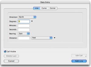
I downloaded a Mac application called Metes and Bounds by Sandy Knoll Software. It’s a neat program with some cool features. Using the application to map a deed is fairly simple. You enter direction (north/south), degrees, bearing (east/west), and distance. Doesn’t seem complicated, does it?
Except I kept coming across metes and bounds descriptions like this:
“…Beginning at a chestnut tree, thence by the other Land of said Henry Hoober West by South fifty six perches to a post, then South South East fourteen perches to a post, thence by land of Ulrich Hoober East South East fourteen perches to a post and thence South East eight perches to a white oak, thence by Land of George Feite North twelve degrees East one hundred six perches to a Hickory and South eighty four degrees seventy two perches to a post, thence North twenty six perches and an half to a Chestnut Tree and North North West thirty perches to a Black Oak by Beaver Creek and thence by other Land of said Henry Hoober South South West forty perches to the Place of Beginning…”
What do I do with that? Some if it looks usable. But how was I supposed to enter “South South East?” None of the available options came close.
So, I scoured the web looking for help. I sort of found what I was looking for. The article I found involved converting those directions into degrees using this “Box the Compass” chart.
Okay. Seems simple. I took the degrees from the “middle”column and entered them in the degrees field of the data entry form, thinking I had my solution. Nope. My maps looked like scribbles.
Apparently, I missed a step in the conversion process. In order to get a bearing that would work in the application, I needed to take the degrees from the chart and convert it.
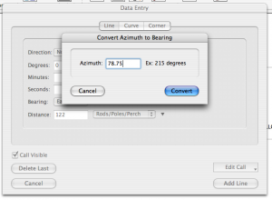
If you click on the down arrow beside the degrees field, one of the options is “Convert Azimuth to Bearing.” If you enter the degrees from the chart there, it will convert it to a bearing that the program can use to recreate the equivalent of “East by North” or “East South East.”
Once I started changing the degrees I’d entered using this method, my maps started looking more like maps and when the deed said “to the place of Beginning” my lines actually met up!
So, if you would like to make plat maps from old deeds for your family research and you use Metes and Bounds, this is how to convert the “old directions” to a useable bearing using degrees.
Cite This Page:
Kris Hocker, "Making a Deed Map from Old Metes and Bounds," A Pennsylvania Dutch Genealogy, the genealogy & family research site of Kris Hocker, modified 23 Nov 2016 (https://www.krishocker.com/making-a-deed-map-from-old-metes-and-bounds/ : accessed 28 Apr 2025).
Content copyright © 2016 Kris Hocker. Please do not copy without prior permission, attribution, and link back to this page.
2 Replies to “Making a Deed Map from Old Metes and Bounds”
Comments are closed.


I just came across your 5 year old deed plotting question but here is a simple way to plot a deed http://www.tractplotter.com perches =p and just follow the instruction on the home page.
Email me if you need help. Terry.
Terry, this actually wouldn’t work straight off the bat with my example. Deed plotting software all use the minutes and degrees. The old metes and bounds descriptions do not use minutes and degrees. The are written like “Beginning at a chestnut tree, thence by the other Land of said Henry Hoober West by South fifty six perches to a post, then South South East fourteen perches to a post, thence…” So, you’d still need the interim step to translate “West by South” into minutes and degrees. That’s the step where I had the problem; that’s where this post came from. I’d still need the “Box the Compass” chart in order to plot the the deed.