Don’t Stop at the Abstract

Here’s my bit of wisdom for a Wednesday: don’t stop your research at the abstract. Find the full document. Why, you ask, when the abstracter extracted all the genealogical information from the document? Ah! But what if they didn’t?

According to Abstracts of York County Wills from 1749 to 1820, Christian Hoover of Heidelberg Township, York County, Pennsylvania wrote his will 10 Feb 1771 and it was proven 21 Mar 1771. His wife Mary was his executor. The abstract lists no one else.

However, if you read the will, Christian stipulates that after Mary’s death there are to be 3 yearly payments of £100 pounds to be paid by her heirs or assigns “into the Hands of Johannes Hoover and Johannes Line in trust for the use of the Surviving Children of my three Brothers namely Jacob Hoover Ulrich Hoover and Henry Hoover…and whereas Johannes Keny son of my sister Ann…unto his brother Henry Keny…”1 That’s some important family information missing from the abstract.

I’ve seen this will referenced as evidence that Christian Hoover, son of Gregor Jonas and Anna Maria (Kreutzer) Hoover, died childless and left his estate to his brother Johannes Hoover of Manheim Township, Lancaster County and his children. From the will we can determine that Christian probably died childless—he doesn’t name or make any reference to having any—and he does leave his estate to his nieces and nephews. However, he lists his brothers as Jacob, Ulrich and Henry, and a sister Ann and her sons Johannes and Henry Keny [Kuny], making no reference to a brother named John. The money from his estate is left in the hands of a John Hoover, but he is not named as being a brother.

2

A Grave Matter

Jacob and Catharine Ritter had nine children who all died between 1834 and 1852, none older than 2 years. They—and other family members—were all buried in the family cemetery on the family farm. Unfortunately, no one is quite certain where the cemetery was located.

In June construction crews working on a development in Penn Township, Lancaster County uncovered 21 gravestones for Ritter children and other members of the Ritter, Longenecker, Wolff and Minnich families, wood and what may be bone. The stones were all stacked on top of one another, indicating that they’d been moved at some time, possibly in order to till the plot. Work at the site immediately stopped.

Now it’s time to decide what to do with the remains. The final decision may be based on determining where the cemetery actually was. So far, the lawyers for the developer have not been able to find a record of the cemetery. The farm was owned in 1869 by Jacob Ritter and in 1879 by Peter Longenecker. Through deeds they’ve determined that some of Peter Longenecker’s heirs were Minnichs. They attempted to contact possible relatives in the area via mailing, but received no response.

The developer would like to move the headstones to Mellinger Mennonite Cemetery, 12 miles away. Grave Concern believes the burial site should be preserved and would like the area fenced off. A Lancaster County Judge has asked them to look into a compromise. A Penn Township manager has suggested the artifacts could be moved to one of two lots on the site that were slated to remain open ground.

What do you think they should do?

For more information you can view an article in the Harrisburg Patriot-News or a follow-up in the Lancaster Intelligencer.

Friday Finds: FamilySearch Wiki

In looking for information about Roxburghshire, Scotland I came across the FamilySearch Wiki information on Scotland. This site includes information on all the Scottish counties, including information on available records (census, court records, civil registration, etc.), maps, and its parishes. The parish pages will tell you about the records available for that parish, including church and civil records.

I found it quite informative—especially the list of parishes in each county and the parish information. The pages also point to another site I’ve used successfully—Scotlands People (the Scottish Records Office)—to find census, birth, marriage and death records.

It also points to a site that has UK census records online—for free! I found my ancestor William Bonnington in the old town of Galashiels in Selkirkshire in the 1841 census. It doesn’t give you an image to view like Scotlands People does, but it will show you the household and its associated information. You can click to view the previous or next household if you want to see more about the neighbors. The data is not 100% for every county for every census, but there is a page to see the database stats for each.

Friday Finds: Scottish Maps

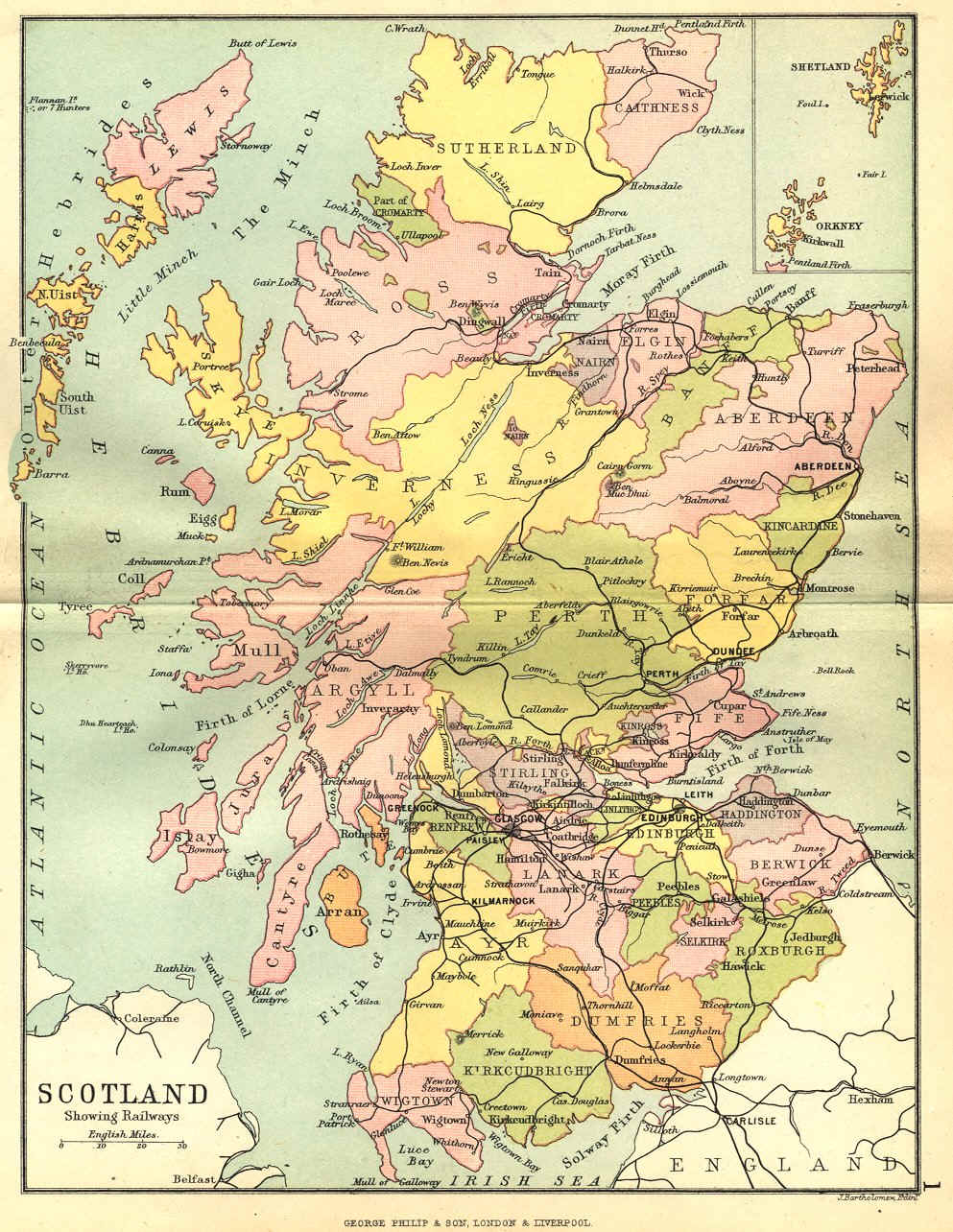
One of the joys of browsing other genealogy blogs—besides getting ideas on how to organize information, which always intrigues the designer in me—is finding new goodies to help my research. So, hat’s off to Kathleen Moore for finding and posting two helpful maps of Scotland in her blog “The Misadventures of a Genealogist”.

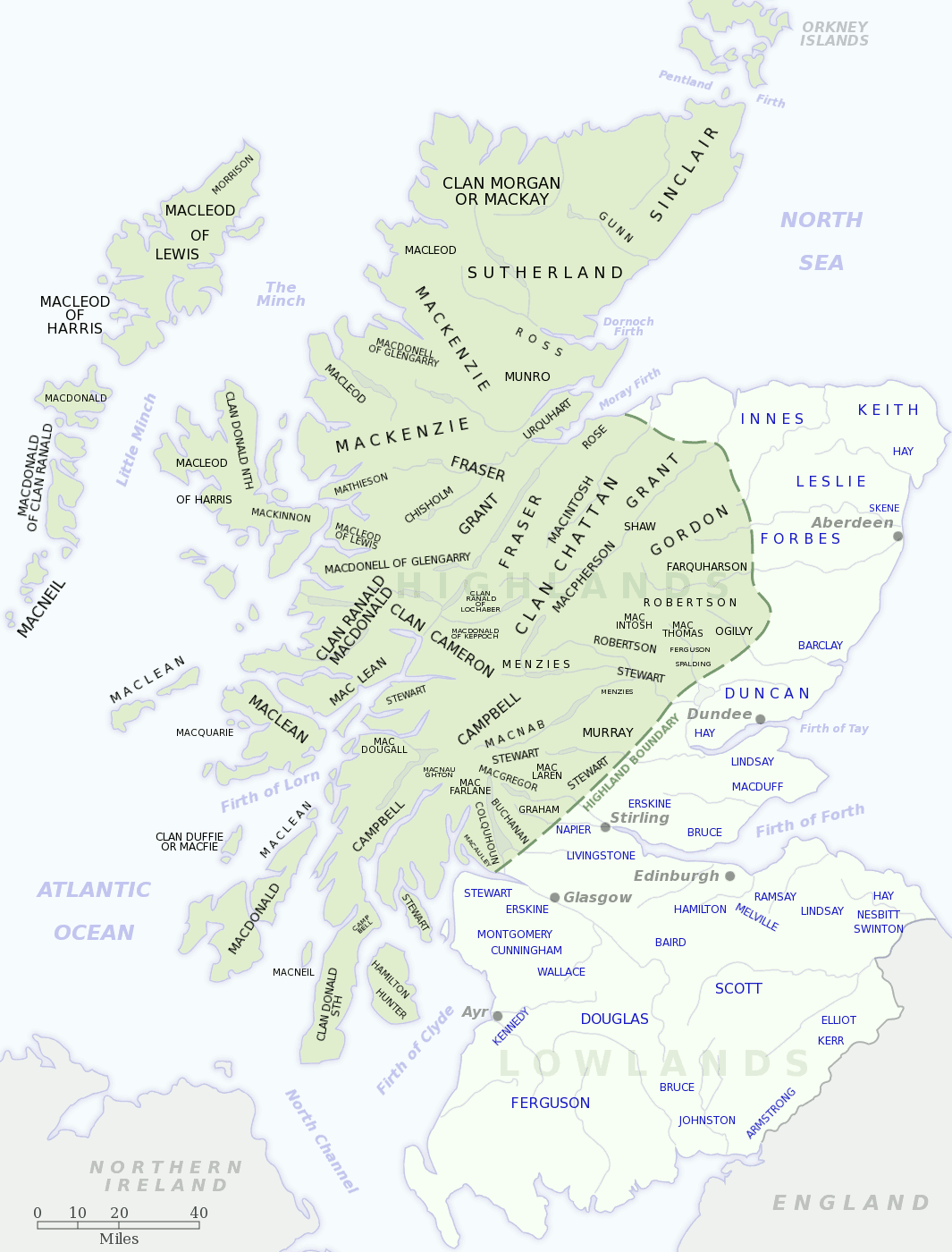
The first is a map showing the locations of the various Scottish clans. The only surname I recognize from my family is Buchanan, shown just to the north of the Highland border line, northwest of Glasgow. My Buchanans seemed to have been miners and were located in Shotts in Lanarkshire.

Scottish Clan map

Scottish Clan map (src: Geneawiki)

The second map shows the administrative subdivisions in Scotland. The majority of my Scottish ancestors lived in Lothian (East, West & Mid), Lanarkshire, and parts of the Scottish Borders.

Scottish Administrative Subdivisions

Scottish Administrative Subdivisions (src: Wikipedia)

Tombstone Tuesday: E.J. & Alavesta Wieder

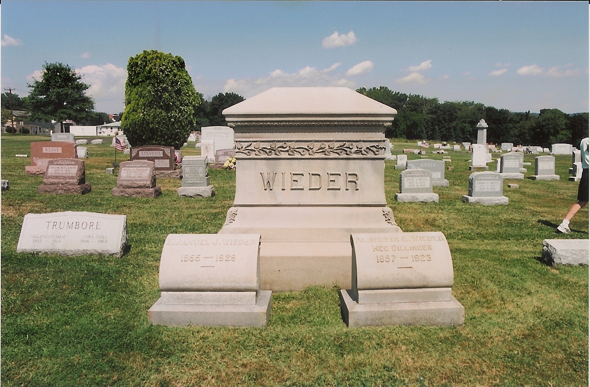
Emanuel J. Wieder (1855-1929) & Alavesta (Dillinger) Wieder (1857-1923)

Emanuel J. Wieder (1855-1929) & Alavesta (Dillinger) Wieder (1857-1923)

Emanuel J. Wieder was born 11 Nov 1855 in Lehigh County, Pennsylvania, youngest son of Saulus and Anna (Mechling) Wieder. He died 26 Jul 1929 and was buried 30 Jul 1929 in St. Mark’s Union Cemetery in Pennsburg, Pennsylvania. He married Alavesta Esther Dillinger on 10 Jun 1878 in Upper Saucon Township, Lehigh County, Pennsylvania. She was born 19 Oct 1857 in Lehigh County, daughter of William and Helena (Person) Dillinger. She died 11 Jan 1923 and was buried 16 Jul 1923 in Pennsburg.

The couple had three children who are also buried in the plot with their spouses: Edwin Joshua Wieder (1880-1960) and his wife Mary Catharine Waage (1877-1970), Cora Anna Wieder (1886-1964) and her husband Vallandingham S. Trumbore (1883-1968), and John William Wieder (1887-1972) and his wife Katharine Jane Greulich (1887-1960).

Do You Know Your Family Health History?

We’ve all heard how diseases can now be predicted by blood tests that search our DNA for specific markers, thus proving that a lot of the most common ailments run through our family lines. Tracing your family’s medical history for illnesses that have affected your parents, grandparents and other relatives can tell you something about the possibilities for your future health. Even the Surgeon General has a campaign—the Family History Initiative—to encourage Americans to learn all they can about their family health history.1

So, how can you go about it? The best way to start is simply to ask family members. Some information may be kept private, but folks will usually talk about the most common illnesses—heart disease, high blood pressure, cancer, and diabetes—or the medications they or family members are taking. Try to get information on family members as far back as you can. Write this information down to share it with your doctor.

Where else can you get health information, especially for relatives your family never knew? Death certificates.

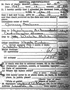
Elmer Greulich Death Certificate Medical Information

Elmer Greulich’s cause of death

We all know death certificates can be helpful in identifying the names of a previous generation—the parents of the deceased. But these documents also provide information on the cause of death and contributing factors. While the cause of death is important, the contributing factors may actually tell you more about the state of your relative’s health.

For instance, the death certificate of my ancestor Elmer Greulich lists his cause of death as a “coronary occlusion.”2 This is a blockage of a coronary artery, which may cause a heart attack. Fairly common. The contributory causes include hypertensive arteriosclerosis and cardiovascular disease, present for 10 years. Not a big surprise given his cause of death.

However, they also include “diabetes mellitus.” This is a major piece of family health information—especially since cardiovascular disease can be caused by diabetes. Knowing that diabetes is present in your family is an important piece of information to share with your doctor. Untreated it can cause all types of nasty damage to your body and lead, ultimately, to death. Given Elmer’s age at death—66—it is more likely that he had type-2 diabetes. Type-1 diabetes left untreated would have probably killed him much younger.

I’ve also learned that some scientists believe that if your mother has type-2 diabetes, you’re more likely to get the disease.3 Elmer’s mother died of gangrene of the foot.4 Diabetes can cause reduced blood flow or lack of circulation, leading to “dry gangrene”. 5 At this point, I’ll probably never know for sure if she had diabetes, but the possibility is there. It’s certainly worth learning the cause of death for her other children, or possibly her siblings.

Obituaries can also provide information regarding a relative’s health. Elmer’s obituary states that he was “partially blind the last four years and in ill health for several years.” So, it is likely that his death was the result of diabetes as changes in vision and blindness can be long-term effects of the disease.6

Where have you found family health history information?

Family Photo Galleries

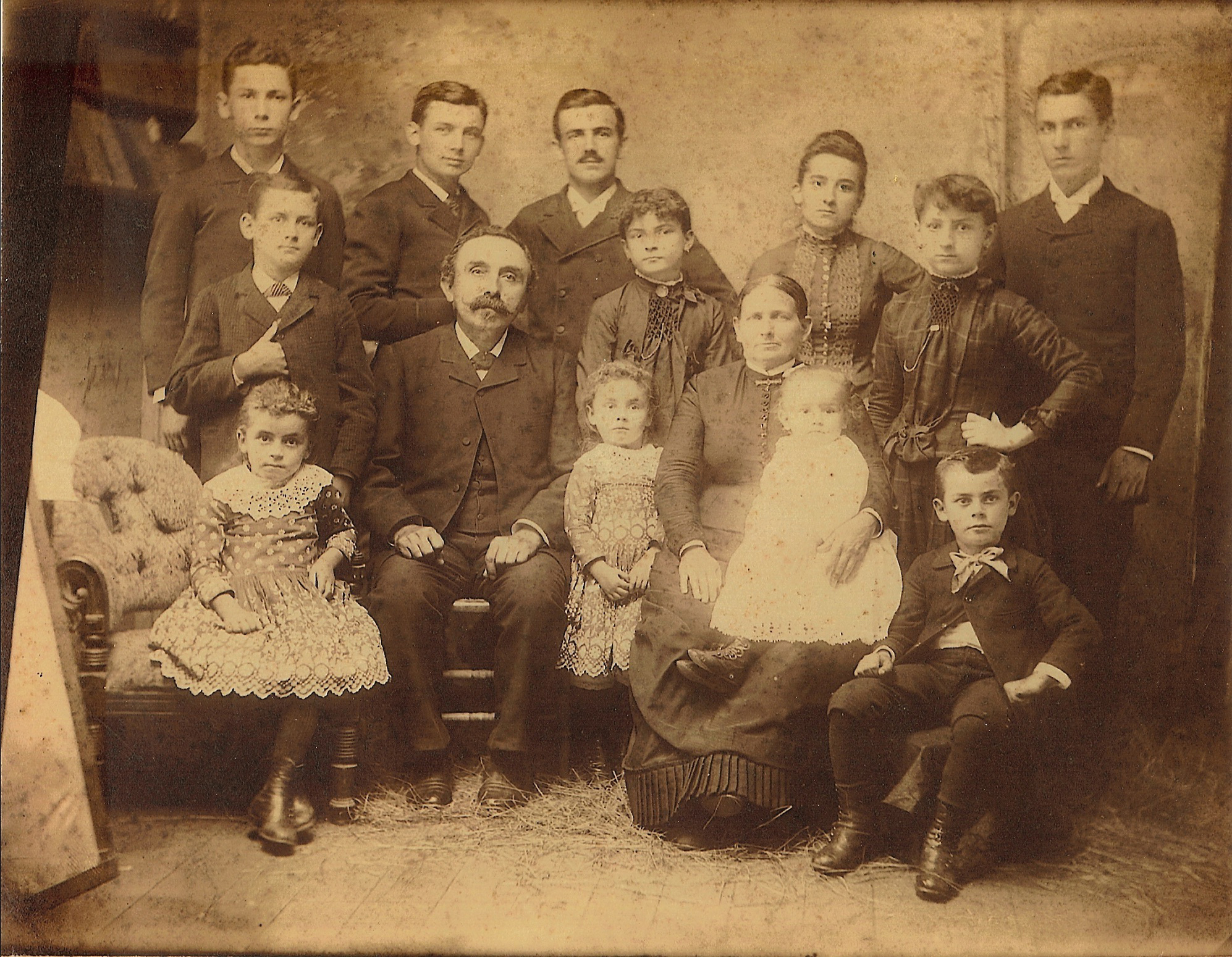
I’ve started uploading additional images to a new set of pages in the Galleries section of this site. The first new page is a family photos page for the Greulich family. It includes family portraits from 1887, 1901, 1929, and 1941/2, starting with a family portrait of the Karl Philipp and Caroline K. (Wolf) Greulich family.

Charles Greulich family (c 1887)

Charles Greulich family (c 1887)

Karl was the first Greulich in our family to settle in America. He emigrated from Haag, Germany in 1855 after the death of his parents Georg Philipp and Anna Margaretha (Wurzel) Greulich. He was 17 years old. Sometime after his arrival, he anglicized his first name to Charles. He married Caroline K. Wolf, daughter of Joel and Elizabeth (Krauss) Wolf of Upper Hanover Township, Montgomery County, Pennsylvania in August 1864. He had previously been married to Caroline’s sister Susanna K. Wolf, who died in 1863. Charles and Caroline had children: Clarence Jefferson (1865-1865), Morris Linton (1866-1931), Irwin Franklin (1867-1934), Charles Ambrose (1869-1942), Chester Daniel (1871-1939), Lily Elenora (1873-1936), Hannah Louisa (1875-1929), Nevin Wilson (1876-1949), Anna E. (1878-1945), Elmer Calvin (1880-1947), Flora (1883-1950), Carrie A. (1885-1963), Katharine Jane (1887-1960). Charles and Susanna had one child Emilie Matilda (1863-1863).

I hope to also be including a family documents gallery which will hold scanned deeds, wills, estate records, etc.—basically any documentation of interest. This will also allow me to link from the footnotes on my family pages directly to the relevant document.

How Many Henry Hoobers in Martic Township?

So, just how many Henry Hoobers were there in the Conestoga (now Pequea)/Martic (now Providence)/Lampter/Strasburg township area of Lancaster County, Pennsylvania? If you’d asked me that question yesterday, I’d have said one. Now today, I’m not so sure…

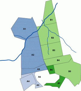
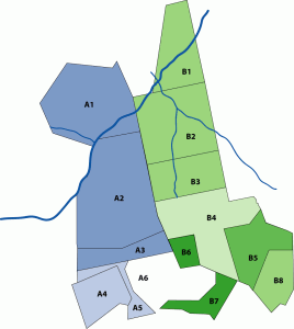
Hoover land patents in Conestoga/Martic Township area

Diagram I: Hoover land patents in Conestoga/Martic Township area

According to the township warrantee maps, there were 5 tracts either warranted to or patented to Henry Hoober in the area where Martic (now Providence), Lampeter and Leacock (now Strasburg) townships meet. [see B1-5 on diagram] They were:

  • B1: 86 1/2 acres warranted to Henry Hoover 24 Jan 1733, patented to Joseph Bosler 28 Mar 1810, Patent Book H2:272
  • B2: 144 acres warranted to Michael Shank, 27 Sep 1717, surveyed 4 Jun 1718, and patented to Henry Hoober 15 Apr 1740, Patent Book A9:180 (Copied Survey Book D82:15)
  • B3: 106 acres warranted to Michael Shank, 27 Sep 1717, surveyed 4 Jun 1718, and patented to Henry Hoober 15 Apr 1740, Patent Book A10:97 (Copied Survey Book D82:48)
  • B4: 68 acres warranted to Henry Hoober 14 Apr 1740, surveyed 10 Nov 1731, patented 15 Apr 1740, Patent Book A9:178 (Copied Survey Book C76:15)
  • B5: 171 acres warranted to Henry Hoover 13 Nov 1744, surveyed 20 10ber (Dec?) 1744, Patent Book AA1:227 (Copied Survey Book A46:77)

In 1733, Michael Shank sold his rights to 250 acres at the junction of Pequea Creek and Big Beaver Creek to Henry Hoober and Jacob Good [tracts B2 & B3 in the diagram]. Henry Hoober took the northern portion and Jacob Good took the southern portion. Jacob Good’s last will & testament, dated 12 Sep 1739, named Henry Hoover as his son-in-law; his daughter was not named.1 There is also a last will & testament for Henry Huber of Martic Township, dated 7 Aug 1757.2 Jacob Huber, son of Hans Huber and owner of tracts A1-A3, named his “loving friend Henry Hoover” as one of the executors of his estate in his last will & testament, dated 9 Jul 1759.3

In 1758, John and Elizabeth (Hoover) Boyers sold their share of the property they had inherited via Henry Hoober’s last will & testament to John Hoover, the other heir to the property. This tract of land was patented in Patent Book A9:180—tract B2 in the diagrams.4

Martic Township Hoover property

Diagram II: Martic Township Hoover property

In 1767, Henry and Catharine Hoober sold to their son John Hoober two tracts of land in Martic Township.5 The first tract was 88 acres from the tract patented in A10:97 or B3 in the diagram. [see left] The second tract was 171 acres from the tract patented in AA1:227 or B5 in the diagram.

Also in 1767, Henry and Catharine Hoober sold to Jacob Hoober 3 tracts of land in Martic Township totaling 137 acres.6 Mapping it out, Jacob Huber’s property matches the residue of tract B3, B4 and part of B5 from Diagram I or B4 on Diagram II. These deeds, to the best of my knowledge, were not recorded until his executors—possibly his sons—sold the land in 1790.

Based on this information, it becomes apparent that there were two men named Henry Hoober—quite likely father and son—living in the Martic Township area circa 1740 at the time the tracts were patented. The elder Henry (?—1757) had children John, Elizabeth, and quite likely Henry Jr. He may have had more. Henry Jr. [the younger], who married a daughter of Jacob Good—quite possibly Catherine as seen in the deeds, had a son John and and possibly another named Jacob to whom he deeded land in 1767.

Henry Jr. may have also had a son-in-law named George Feite. His name appears in the metes and bounds for one of the tracts sold to John Hoober on the boundary for tract B5 (B8 on the diagram). Additionally, the name Ulrich Hoober appears as a neighbor (to the south) in the metes and bounds for tracts B4 and B5 sold to Jacob and John Hoober, respectively. He may have been another relative of Henry Jr.

Tract B6 and B7 also belonged to Hoovers. Tract B6 was warranted to Martin Huber 6 Apr 1803 and patented to him on 13 Nov 1811. Tract B7 was warranted to Jacob Huber 14 Mar 1796 and patented to him on 12 Apr 1803. These two men could have been grandsons of Henry Hoober Jr. or Jacob Huber. If at least part of B7 belonged to Ulrich Hoober at one point, he must not have patented it.

As always if you have additional information or questions on any of the people in this post, please contact me or leave a comment.

Making a Deed Map from Old Metes and Bounds

As you may know I’ve been working with land records a lot recently. I started with the surveys available for Lancaster County land warrants and patents, grouping them by township and name. I’ve also been going through Hoover family deeds for Lancaster County and assigning them to the appropriate Hoover family. My goal is to tie the deeds not only to a particular Hoover family, but also to a particular tract of land back to the original patentee. Sometimes, the information is readily available in the deed itself; sometimes it requires some backtracking through deeds.

As part of the process, I’ve been trying to create deed maps for deeds where I have questions—especially where the land is being divided amongst the heirs. I like to think that I’m a smart person, but I had some problems figuring it all out. Since I didn’t really find an answer online, I thought I’d share what I learned.

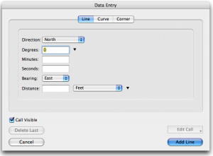
Data Entry form for Metes and Bounds

Data Entry form for Metes and Bounds

I downloaded a Mac application called Metes and Bounds by Sandy Knoll Software. It’s a neat program with some cool features. Using the application to map a deed is fairly simple. You enter direction (north/south), degrees, bearing (east/west), and distance. Doesn’t seem complicated, does it?

Except I kept coming across metes and bounds descriptions like this:

“…Beginning at a chestnut tree, thence by the other Land of said Henry Hoober West by South fifty six perches to a post, then South South East fourteen perches to a post, thence by land of Ulrich Hoober East South East fourteen perches to a post and thence South East eight perches to a white oak, thence by Land of George Feite North twelve degrees East one hundred six perches to a Hickory and South eighty four degrees seventy two perches to a post, thence North twenty six perches and an half to a Chestnut Tree and North North West thirty perches to a Black Oak by Beaver Creek and thence by other Land of said Henry Hoober South South West forty perches to the Place of Beginning…”

What do I do with that? Some if it looks usable. But how was I supposed to enter “South South East?” None of the available options came close.

So, I scoured the web looking for help. I sort of found what I was looking for. The article I found involved converting those directions into degrees using this “Box the Compass” chart.

Okay. Seems simple. I took the degrees from the “middle”column and entered them in the degrees field of the data entry form, thinking I had my solution. Nope. My maps looked like scribbles.

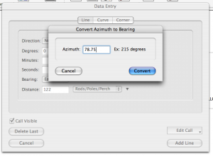
Apparently, I missed a step in the conversion process. In order to get a bearing that would work in the application, I needed to take the degrees from the chart and convert it.

Convert Azimuth to Bearing

Convert Azimuth to Bearing

If you click on the down arrow beside the degrees field, one of the options is “Convert Azimuth to Bearing.” If you enter the degrees from the chart there, it will convert it to a bearing that the program can use to recreate the equivalent of “East by North” or “East South East.”

Once I started changing the degrees I’d entered using this method, my maps started looking more like maps and when the deed said “to the place of Beginning” my lines actually met up!

So, if you would like to make plat maps from old deeds for your family research and you use Metes and Bounds, this is how to convert the “old directions” to a useable bearing using degrees.

From Deed to Land Warrant and Back Again

For some reason I got stuck on John Hoover today when I was deciding where to start on my Huber/Hoover work. Which John Hoover, you ask? I was hoping to find information on John Hoover (Huber), son of Hans Ulrich (Woolerick) Huber of Conestoga Township, Lancaster County, Pennsylvania.

I don’t have much information on him. I believe he may have been born in Lancaster County, Pennsylvania circa 1726. He purchased land from his father’s estate from his siblings—Jacob Hover and Barbara his wife, Henry Shank and Anna his wife, Jacob Boyer and Maria his wife, Elizabeth Hover, Ulrick Hover and Henry Hover all of Pennsylvania—in 1759.1 I had seen the possibility that this John Hoover was also the John Hoover of Necessity, Maryland alluded to on a message board and wanted to see if I could find evidence in the data I’ve acquired.2

So, I was looking at deeds and land patents for John Hoover for leads. John Hoover of Necessity was in Maryland by 1769 when he received a deed for “Harry’s Grove” from the David Watson estate at the request of Michael Miller, to whom it had been sold but who had not received a deed. 3 If John Hoover of Necessity was the son of Ulrich Hoover of Conestoga Township, then he would have had to have sold his Lancaster property at or before 1769.
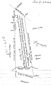
John Hoover 1744 Martic Township land patent

John Hoover 1744 Martic Twp land patent

I did not find any deeds for John Hoover selling land in Conestoga (now Pequea) Township. I found a deed for John Hoover purchasing land in Conestoga Township. On 28 May 1754, John Hoover purchased 110 acres on Pequea Creek from Jacob Eshleman and Pebela his wife.4 There were several land patents for John Hoover in the same general area—one for 105 acres adjoining Ulrich Hoover’s tract in Martic (now Providence) and Conestoga Townships and another for 25 acres in Conestoga Township.

Figuring the land adjoining Ulrich’s was the best bet, I followed up on that first. This tract—although patented to John Hoober—had first been the land of Jacob and Barbara (___) Hoober from Martin Kendig. 5,6 It was sold by John’s heirs—Jacob Hoover and Margaret his wife, John Hoover, Henry Hoover and Mary his wife, Christian Hoover, Peter Hoover, Anna Brenneman, Frena Hoover, and Barbara Hoover all of Lancaster County—to their brother Abraham Hoover in 1785.7 So, this may not be the John Hoover I’m looking for.
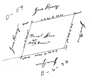
John Hoover 1752 Conestoga Township land patent

John Hoover 1752 Conestoga twp land patent

Next I looked at the land patent for the 25 acres in Conestoga Township patented to John Hoover in 1752.8 Looking at the survey, I was confused. I saw no reference to it being for John Hoover. This tract was apparently patented to Michael Hess in 1744. Had I made a mistake? I double checked the index and looked the survey up again on the internet. No, that was the correct file.

I spent some time pouring over the Township Warrantee maps, but couldn’t find matching land for John Hoover, Jacob Good or Jacob Rubely. I found Michael Hess, but it wasn’t matching up.

So, I looked up the survey for the adjoining land of Jacob Good. 9 It made no reference to Jacob Good, but instead showed the land as patented to Thomas Lindley. Now I was still confused, however the name Lindley rang a bell.

Jacob Eshleman Conestoga Township tract

Jacob Eshleman Conestoga Twp tract

The land John Hoover purchased from Jacob Eshleman bordered on land of Thomas Lindley. Figuring that John Hoover’s property bordered on this land, I compared the description of the tract borders from the deed to the survey to see where they met. To my surprise, they matched! And moreover, not only was this Lindley tract the same property patented Jacob Eshlemen in 1744 and sold to John Hoover in 1754, but it also abutted the property allegedly patented to John Hoover in 1752.

Now I knew that I had the correct pieces of property. So, I printed off the surveys for both tracts. Each survey comes with two pages, the survey drawing and information and the reverse page that usually gives the date, location and patentee name. Looking at the reverse pages of these two surveys, I saw that they clearly stated that the patent surveys were for “John Hoover in Right of Michael Hess” and “for the use of Jacob Ashleman.” The moral here: examine the whole document before freaking out!

So, I still don’t know if Ulrich’s son John Hoover is the John Hoover of Necessity—that will take much more work. I don’t even know if these documents belong to John2 Hoover (Ulrich1). However, I have, I believe, tied these three documents—the two patents and the deed—together. It is highly likely that John Hoover of Conestoga Township, having patented 25 acres in the township in 1752, purchased the adjoining land from Jacob Eshleman in 1754.

Now I need to find out what happened to this property. Did he sell it or was it passed down to one of his children?

If you have any information on these families, please I’d love to see it!